
×
Hunze Valley
Aquabattery
1/9
Development of the Hunze Valley from the penultimate Ice Age
Climate challenges for Hunzedal
Aquabattery
Aquabattery turns the disbalance between excess rainfall and a shortage of rain into a local and natural source of fresh water. The stream running from the Hunze rivervalley is becoming a sponge landscape which makes optimal use of the supply of fresh seepage water from the Drents Plateau, which is located on higher ground. The landscape charges itself up like a battery during the wet winter months. This ensures that there is enough drinking water during the dry summer months and promotes the development of natural wetlands. This also eliminates the dependency of the water supply from the IJsselmeer.
A sponge landscape offers a perspective for is perfect for a wide range of projects. For example, it prevents subsidence of the peat soils and CO2 is no longer emitted but stored away in new forests and – over time- new peat marshes. With a guaranteed fresh water supply, the agricultural transition in the adjacent Veenkoloniën can get underway. The biodiversity and the economic and recreational value of the area is increasing with the emergency of a vast wetland. The area forms a place of refuge for migrating wetland birds. Together with Geopark de Hondsrug and the Drentsche Aa, the Hunze Valley forms a vast, new, formidable national landscape.
A sponge landscape offers a perspective for is perfect for a wide range of projects. For example, it prevents subsidence of the peat soils and CO2 is no longer emitted but stored away in new forests and – over time- new peat marshes. With a guaranteed fresh water supply, the agricultural transition in the adjacent Veenkoloniën can get underway. The biodiversity and the economic and recreational value of the area is increasing with the emergency of a vast wetland. The area forms a place of refuge for migrating wetland birds. Together with Geopark de Hondsrug and the Drentsche Aa, the Hunze Valley forms a vast, new, formidable national landscape.
Hydrological principle Aquabattery
Voornamelijk agrarisch landschap, gericht op afvoeren van overtollig water
Waterbatterij, sponslandschap dat zich oplaadt met zoet water
Cross-sectional hydrological system Aquabattery Hondsrug- Hunzevallei
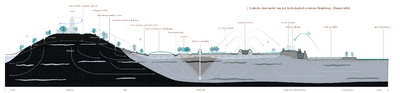
Image of the bog development along the flank of the Hondsrug
image by Bureau B+B / MARTA pictures
Map
The operation of the Aquabattery in three cross-sections: city system, downstream and ppstream
Water uit de industriezone wordt met helofytenfilters gezuiverd en in de waterbatterij geleid.
In het benedenstroomse deel van de vallei ligt de Hunze in de boezem: hoger dan het landschap. Drempels in de boezemdijk zorgen dat het rivierwater het laagveenmoeras in kan stromen.
Water system, biotopes and recreational networks in Hunzedal
Het Hunzedal is gericht op het opvangen en vasthouden van verschillende waterstromen. (1) Op de Hondsrug wordt infiltratie naar de watervoerende laag in de ondergrond (aquifer) gestimuleerd. (2) Het stroomdal wordt een veenmoeras dat onder invloed staat van de dynamiek van de rivier. (3) De industriezone en de rand van de Veenkoloniën vormen een hydrologische buffer. Deze voorziet in waterzuivering en piekberging.
Het Hunzedal wordt een rijk natuurgebied met biotopen die ontstaan onder invloed van de overgang van hoog naar laag. (1) Op de Hondsrug worden naaldbossen omgevormd naar een open boslandschap met heide en zandverstuivingen. (2) Op de flanken van de Hondsrug liggen houtwallen en natte graslanden. (3) Het stroomdal wordt een laagveenmoeras dat onder invloed staat van de rivier. (4) Op de overgang van de flank naar het stroomdal liggen kansen voor de ontwikkeling van hoogveen.
Door de koppeling aan Geopark de Hondsrug ontstaat een groot nieuw nationaal park. De overgangen van hoog naar laag bieden ongekende recreatieve mogelijkheden. (1) Ringvormige doorgaande routes verbinden de Hondsrug met het stroomdal. (2) Een fijnmazig netwerk van wandelpaden ontsluit de toegankelijke delen van het veenmoeras. (3) Kanoroutes maken het gebied vanaf het water beleefbaar. (4) Station Kropswolde wordt de poort naar het grootste laagveenmoeras van Noordwest-Europa.
Ecolodges near railway station Kropswolde
image by Bureau B+B / MARTA pictures
Three subdivisions: Glimmen, Kropswolde en Coendersborg
Op de flanken van de Hondsrug vormen houtwallen en droogvallende sloten een coulisselandschap. Aan de voet wordt helder kwelwater opgevangen in een moeraszone, waarna het infiltreert. Op de overgang tussen de flank en het stroomgebied kan op den duur hoogveen ontstaan.
Hoogezand ligt aan de industriezone langs het Winschoterdiep. Hier wordt het effluent van de waterzuivering gezuiverd door wilgen en rietplantages. Station Kropswolde wordt de poort naar het laagveenmoeras. In de moerasbossen liggen recreatieve routes en ecolodges.
Het stadswatersysteem van de zuidelijke stadswijken van Groningen wordt afgekoppeld en langs de flanken van de Hondsrug geleid, waar het infiltreert. Vanaf de Hunzeboezem wordt een zijstroom doorgetrokken en via een oude loop de stad ingeleid. Deze ‘lokstroom’ wordt aangesloten op het Reitdiep, waardoor de natuurlijke vismigratieroute in ere wordt hersteld.
The future landscape of the Hunzedal
About the designers
Bureau B+B
Since its founding in 1977 Bureau B+B built up a rich experience. At the same time, we keep attracting young talent. Because the bureau renews itself, it keeps finding fresh solutions to current themes. Each design can be recognized by its poetic clarity. The framework is powerful, the details are subtle and refined. Every design starts with research of the existing elements, traditions and culture of the location. A clear, functional foundation is essential to create opportunities for gradual transformation.
The working field of B+B is wide: from urban public space, parks, new residential areas to water works. The agency consists of 12 landscape architects and urban planners, led by Gert-Jan Wisse and Jeanette Visser.
The working field of B+B is wide: from urban public space, parks, new residential areas to water works. The agency consists of 12 landscape architects and urban planners, led by Gert-Jan Wisse and Jeanette Visser.
Explore other projects

Partners:
© 2021 Sponsland | Klimaatadaptatie Groningen