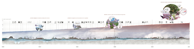
Warning: file_get_contents(https://vimeo.com/api/v2/video/500976483.php): failed to open stream: HTTP request failed! HTTP/1.1 404 Not Found in /shared/usr/sponslandnl/DOMAIN/HTML/lib/php/custom.php on line 242

Warning: file_get_contents(https://vimeo.com/api/v2/video/500931399.php): failed to open stream: HTTP request failed! HTTP/1.1 404 Not Found in /shared/usr/sponslandnl/DOMAIN/HTML/lib/php/custom.php on line 242
sponsland

sponsland

move through the area
×
Reitdiep

++ Water Heritage

6/9

Reitdiep
The current landscape of the Reitdiep River area has evident qualities, characterised by its cultural heritage, with beautiful small scale parceling and visible history. This landscape is formed under the influence of the sea and the rivers. Periods in which fresh water creeks meandered through the landscape and deposited sand, alternated with periods when the salty seawater came far inland depositing clay.

These water dynamics formed 3 different landscape typologies:

1. the water dynamic landscape with the now elevated more sandy zones of the former river valleys,
2. the low-lying oval shaped islands with more clay soils,
3. the polder landscape further away from and less influenced by the water dynamics.

Also the “wierden” are still visible; high man-made mounds which were built for dry habitation from 600 BC till around 1200 AD.

The expected rising of the sea level, longer periods of drought and the increase in ground water pumping for irrigation, creates the process of salinisation and a decrease in availability of fresh water. The existing water system, with fixed water levels and rapid drainage of excess water, intensifies this process. In the long run, it is inevitable that the use of the landscape will change. For the coming decades, the challenge will be to develop a resilient water system that will benefit new, circular agriculture, biodiversity and the identity of the landscape.
Water dynamics will again form cultural heritage landscape
The rich cultural heritage in this landscape is formed by the dynamics of its watersystem
The present landscape: water dynamic zones, the lower island and polders
++ Water Heritage
Salinisation is held back by enlarging the underground fresh water lens; through retaining rainwater, enlarging the surface water, and introducing varying water levels. Fresh water from the higher sandy grounds of the Drents Plateau flow in to the Reitdiep River, with a new water connection on the west side of the city of Groningen. This adjusted water system with higher and varying water levels is separated from the water system in the canals and the inner city of Groningen. This makes the water system of the Reitdiep River zone independent from the delivery of fresh water from the IJsselmeer and ensures a good water quality. This robust water system is self-sufficient, with a natural runoff from the source to the sea and a high retention capacity.

The irrigation of a large area is guaranteed, creating opportunities for a resilient agricultural landscape. The re-introduction of water dynamics in the area is not only protecting existing cultural heritage, but also creates the very future of it.
read further
collapse
The present landscape: water dynamic zones, the lower island and polders
Proposal to connect Reitdiep to Drentse Aa
The irrigation of a large area is guaranteed, creating opportunities for a resilient agricultural landscape. The re-introduction of water dynamics in the area is not only protecting existing cultural heritage, but also creates the very future of it.
Landscape typology determines water retention possibilities
Water retention in the former creek meanders:
Increasing the nature network and the aquatic biodiversity
Water retention in the lower-lying rivermeanders:
agroforestry, woodproduction, reduction of CO2 emission
Water retention in lower-lying agricultural area:
More water for agriculture and nature development
Water retention in lower-lying, connected former creek meanders:
Increasing the nature network and water supply for mixed innovative farms, pixel farming, water-based cultivation
The current differences in height and soils provide for local water retention options, which vary from larger former creek meanders to very small ditches on agricultural parcels. The current system of water drainage pipes is transformed towards a small scale pattern with ditches on the agricultural parcels; as was used in earlier times. In these small ditches the water levels vary according to season and land use. This in turn allows a variety of crops to be grown, contributing to a smaller-scale landscape. Making use of these differences in specific water interventions will once again make the geomorphology, the heritage and the landscape typologies visible.
read further
collapse
Image of the new water structure along Reitdiep and on the islands
Three landscape typologies embracing future dynamics

The zones along the Reitdiep River turn into a wide nature reserve with woods, huge amounts of water edges with increased biodiversity, including a spawn area for fish far upstream. The green/blue zones of the water dynamic landscape typology form the inverted shape of the diverse, small-scale agricultural production landscape of the three oval-shaped islands landscape typology. The larger, lower-lying areas in the landscape typology of the polder landscape enable large water retention areas, as well as larger energy production areas, creating its own identity. All three landscape typologies will thus have very specific identities in the future, which emphasize their history and cultural heritage.
read further
collapse
Development of agriculture until 2120
The desire to use less surface for agriculture and diminish CO2 emissions, will slowly shift society towards less dairy based food consumption and more locally produced food. Agricultural production will transform towards smaller-scale horticulture and mixed crops. With a temperature rise of around 4°C, our agriculture will begin to resemble the agriculture that is currently found in Spain. The renewed water system will provide as much fresh water as possible for as long as possible. Over time, a shift to more salt-resistant crops will move further inland.
read further
collapse
Scale-model film of MORE
500976483
500931399

About the designers
MORE Landscape i.s.m. VE-R
MORE landscape is a designbureau for Landscape and Urbanism, MORE landscape works from detailed product designs up to visions on world scale, and is involved in urgent design discussions and research. MORE landscape always works in mixed teams with multiple disciplines, and in different combinations of design teams.

Hanneke Kijne is the founder of MORE landscape. She started the bureau in 2019. She was projectleader, head designer and shared owner of HOSPER. Since 2018 Hanneke is head of landscape at the Academy of Architecture in Amsterdam. In addition, she is member of the board of the NHBos foundation. Hanneke Kijne gave her entrance at the Academy in Amsterdam in September 2018 and published the lecture: ‘MORE landscape, the need for a new perspective’.